A Greek political map of Europe is also a map of the Greek political mindset
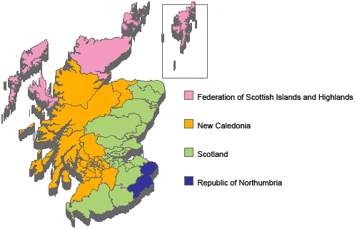
Yesterday I published a little fable - "The Former Scottish Constituency of Northumbria"- intended to make the Macedonian name dispute between Greece and FYROM intelligible to anyone who understands the geography of the UK, but not of the Balkans.
It is very interesting to consider how much of our world view is shaped by maps and geographical labels, and a look at a Greek map of the world can be very telling. One of the places I went to watch football near Chania is in Agia Marina, called The Kiss Bar, which is a fantastic place with plenty of screens, free wifi and cheap beer. It also has a massive Greek political map of Europe on one wall. And when I saw political, it really is political.
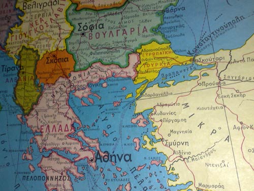
Take the Balkans region. On the map, the country that is either known as FYROM or simply Macedonia, does not have a name. You can see from ΕΛΛΑΔΑ and ΑΛΒΑΝΙΑ that country names are given in a pink font. All FYROM has marked is the capital Σκοπια.
This is pretty common on Greek television news. Rather than "Macedonia says...", or "The Former Yugoslav Republic of Macedonia says...", the news will say that "Skopje says...". There are plenty of Greeks for whom the inclusion of the 'M' word in that country's name is utterly unacceptable, even if it were to be combined with a qualifier to become 'Slavic Macedonia' or 'Northern Macedonia' or 'Upper Macedonia'.
Then look at Turkey on the map. This map is labeled a political map of Europe, and it is obvious that the cartographer does not consider that Turkey in is Europe. Well, apart from the small bit between Greece and the Bosphorus Strait anyway. The Western portion of Turkey is coloured yellow, as part of Europe. The vast majority to the East is white and thus marked outside of Europe.
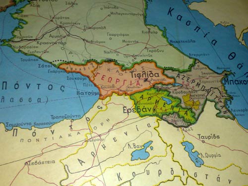
This is a carefully considered decision, and nothing to do with how far East you have traveled, because further into classical Asia, Georgia, Armenia and Azerbaijan are all depicted in colour as fully European nations.
There is another peculiarly Greek quirk about the depiction of Turkey.
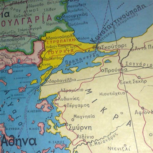
You'll be aware of a city called Istanbul, named officially that way since 1930. Not on this map, where the modest legacy of Roman Emperor Constantine I is still on show - Κωνσταντινούπολη [Constantine's City]. Likewise, Izmir is written as Σμύρνη. Izmir may not be politically "in" Europe as far as this map is concerned, but it is important to keep alive the memory of Greek Smyrna.
Now, I must try and find some Turkish and "Macedonian" maps of the region to compare...
There is nothing to compare. On Macedonian maps Macedonia is Macedonia, Greece is Greece and Turkey is Turkey. In other words, we live in the real world, unlike our little fascist fanatic neighbours in the south.
This map is NOT broadly representative of the Greek perspective and certainly NOT what is being taught in its schools. Greece desires good relations with ALL its neighbours, including Turkey and FYROM. Greece is one of the strongest supporters of a European Turkey and has stated this publically repeatedly. In FYROM the Greek people are the largest economic investors in that country and they continue to invest in their neighbour. Relations with FYROM are strained due to the fact that it has territorial aspirations in Greece. Ditto for Turkey, who does not respect Greek sovereignty over many areas of its established borders. In both cases, the sides have much more in common than not, and it would be a great tragedy if they could not resolve their differences.
Why are you surprised that Asian part of Turkey is considered ...Asian??
The peninsula is called Anatolia or Asia Minor..It's a matter of geography,not politics.
As for the lack of name on FYROM,it is possible that the map was published between 1991(independence of FYROM) and 1995,when the two countries agreed on FYROM.
Finally, you have to look upon a British political map,and wonder why it's written "Athens" or "Corfu" on it...and not "Athina" and "Kerkyra".
Simply..in Greek ,"Istanbul" is called "Konstantinoupoli" and "Izmir","Smyrni"..
(In fact "Konstantiniye" was the official name of the city in Turkish until 1930's when it was changed by Mustafa Kemal Ataturk to "Istanbul".
Europeans need to stop promoting Greece's racism it makes you all look like idiots.
If you really want to see something interesting, check out the official war map from the Imperial War Museum - when Britain was helping Greece partition Macedonia back in 1912-1913.
The Macedonian and Turkish place names were the ones used by the military, the new Greek names in Macedonia hadn't been forced upon the population yet, nobody would have understood them prior to the 1920s.
BTW, the proper Macedonian name for Istanbul or Constantinople is Tsarigrad or "The Imperial City".
I hate to break it to you racist Greeks posting here, but it is not FYROM, it is The Republic of Macedonia as recognized by over 120 countries in the world. USA, Canada, Turkey, India, Russia and China just to name a few.
This is 2009. Wake up people. Greece must stop its racism toward its minorities, mainly towards Turkish and Ethnic Macedonians.
Martin, I don't think our British maps are are any better - if you look at any British map of Europe you'll see "Spain" instead of "Espagne" and "Germany" instead of "Deutschland" and "Rome" instead of "Roma" - we translate place names into the English language and into words which are familiar to us i.e. how we've known these places for centuries. The Greeks are doing the same thing - they only know Istanbul as "Constantinople" since it was part of their history and this is how they've always known this city. (Also, the map you've shown shows "Istanbul" written in Greek below "Constantinople" so it isn't as secretive as you make it out. Maybe we should start saying "i'm going to Espagne for my holidays" before we criticise how Greeks should be pronouncing place names and spelling them in their own language on their maps. Any map with just "Falkland Isles" is a political map, it should also have "Malvinas" but most British maps only have the former. Our maps are just as political as the Greek maps.
It is a plain fact that Turkey geographically is not a part of the geographical continent called Europe. This is not meant as a slight, as you seem so bent on inferring. How could it be, when the map has the Greek names for many of the towns in Turkey, underlining the fact that Greece's own history is intimately tied to this part of Asia? I think you're being a tad sensationalistic.
Very true Keith, but we haven't recently been vetoing German membership of the EU or NATO on the basis that the Germans would prefer to call Germany "Deutschland"
Yet Armenia, Georgia and Azerbaijan are?
Martin,
I hate to break the news to you, but Greeks don't call France as "France", but they still use the name "Gaul" or Gallia in Greek. We also call Switzerland as "Helvetia". We don't have another name for Constantinople. Constantinople used to be the capital of the Byzantine Empire for over 1,200 years. This is the only name we know. We call the Jews as "Evraioi" which is their ancient name as well.
As for FYROM, we cannot call them Macedonians just like we can't call Libyans or Egyptians as Cretans or Spartans or generally any people who have nothing to do with ancient Greek history.
And since you like showing maps, why don't you show us the map of "Greater Macedonia" that many nationalists of FYROM have been promoting around the internet with Thessaloniki as it's capital.
>>>>Yet Armenia, Georgia and Azerbaijan are?
Errr...yes...
But please don't let mere facts get in the way of an otherwise sensational story. ;-)
Here's a little contribution for the better resolving of this complex
We all know that Greece is a creation or an experiment of Europe, 100 years later the creation or experiment has became a nightmare for the EU and NATO.
My opinion is that many creations that were formed like Yugoslavia and Soviet Union have collapsed and dismantled. Greece is next, built on a false history with all different minorities, sooner or later it will collapse like Yugoslavia and the Soviet Union.
I give Greece 20 years max if their lucky.
I just got back from Greece a few weeks ago and many inhabitants in Northern Greece (as it was known before it was renamed to Makedonia) can speak Macedonian, or at least understand it. Officially in Greece there is no such thing as a Macedonian language or ethnicity, however unofficially everybody knows it exists and call it the local dialect, which is different to spoken Greek.
Greece needs to wake up and understand that there are not only Macedonians living within its borders, but also to the north who call themselves Macedonian and live in a country called the Republic of Macedonia who is also recognised by 120+ countries, including USA, Russia, China, India, UK etc etc.....
The thing is Goce, for me the significant fact is that I would expect a map labelled a political map to represent single political entities as a single political entity - not cut it in half just because it straddles the Dardanelles and that is the only geographical boundary illustrated on the map, no?
Now that's a "principle" you're pulling out of your hat! How come you didn't get bent out of shape that the map did not extend all the way to Vladivostok, then? Russia, too, straddles two continents, and, as is proper, maps of Europe include only European Russia (i.e. till the Urals).
Look, apart from the Macedonian thing, which the Greeks have been quite transparent about, the map you found has done no graver "sin" than the mainstreeam map I posted from WorldAtlas.com. It is not at all unusual to distinguish European Turkey from Asian Turkey. Heck, even the Turks have signs on each side of the Bosporus saying, "Welcome to Europe/Asia," as the case may be.
I think your article and nitpicking say more about your own political mindset than that of the Greeks (for whom, if I may read your subtext, you don't seem to have to have too much affectiom).
Have a good week.
Sorry, Kallimachos, but your comment is obsolete. Tourkia is also a "new" name. Before it was the Ottoman Empire. Constantinople has been renamed and since then it is called Istanbul. Maybe in Greek you would name it Istanboul but never Constantinople. This is a map and not "historical" material. This fuels more conflict against Turkey.
Then I think that Germans would allow a Slavic people around being called Bavarian in NATO and EU. Or Turks would allow "Ottoman" (not Turkish) people and country in NATO.
Maybe UK would allow Greeks getting EU membership as Britons. (Do you have any other important toponyms in UK? = are all toponyms in UK that unimportant?)
Think before deriding.
Istor
Macedonian, therefore Greek.
Goce, you couldn't be more wrong. I lived there for the best part of three years, and found Crete to be an amazingly friendly island with wonderful people on there. I loved it. The reason for posting this article, and the fable about FSCoN was to explain to my mostly British and American audience here a bit about how deeply the divisions in the Balkans still manifest themselves. The strength of the comments they have attracted from both sides is certainly testimony to that.
LOL! "Why that's preposterous! Some of my best friends are Jewish!"
You article is uninformed and tendentious. The positive responses to it have been from certain Macedonian nationalist fanatics, who see you as an ally--"You're right, Martin, those Greeks really suck"--, the reproofs from certain Greeks trying to answer your loopy logic.
In the meantime, you get to boast about the number of responses to it, and how--voila!--it proves your original assertion (although you'll need a few Turkish posters in here too to clinch it). It's great how the tabloids work, init?
Hehe, is not the irony delicious here! Why did you call it "Dardanelles" and not "Çanakkale Boğazı" as the Turks call it?
Fair enough Goce, you've rumbled me. It is my own prejudice that leads me to notice a nameless FYROM/Macedonia and a truncated Turkey with 18th century names on this map. I should have realised that maps are produced in a cultural vacuum. To paraphrase one of my Jewish friends: "Who you gonna believe, me or your own eyes?"
Of course FYROM/Macedonia is nameless. Greece does not recognize that country as Macedonia. After spending "the best part of three years" in Greece, you'd think someone would have picked up on that one.
As for the "truncated Turkey with 18th century names," these are your own wild imaginings. Turkey is not at all truncated; it's all there. Only European Turkey is distinguished from Asian Turkey. I've shown you a mainstream English language map that does the exact same thing.
And I'll ask you again: Why didn't you complain about Russia being "truncated" on this map? I'll tell you why: because it wasn't useful to the preconceived tale you wanted to tell.
The names are not 18th century names either; they're 21st century names--they're the names the Greeks use to this day. Why is it OK for YOU to use names like Dardanelles, but it's not OK for the Greeks to use their own names for places? British exceptionalism?
Finally, in your article you claimed that "You'll be aware of a city called Istanbul, named officially that way since 1930. Not on this map, where the modest legacy of Roman Emperor Constantine I is still on show - Κωνσταντινούπολη [Constantine's City]."
Yet, lo and behold, the most basic examination reveals that this very map does write the name Istanbul, in brackets, below the name Constantinople. Did you even notice that? Nope...
So in answer to your Jewish friend's question, I'd trust him, not your eyes. Your eyes see only what they're looking for, not what's there.
Et voila! So the map does reflect the politics?
"After spending 'the best part of three years' in Greece, you'd think someone would have picked up on that one."
I think I'll leave you to it, Goce, as both of us seem to be exhibiting selective vision here. Maybe I can direct you again to the first part of this series of blog-posts - "The Former Scottish Constituency of Northumbria"?
There is no question about Greece's "Megali Idea" or Big Idea. Anything it can be translated into Greek, it must be Greek. This is how the Greeks perceive the world today, but no different than a century ago.
>>>>>>>>>>>>>>>>>Et voila! So the map does reflect the politics? "After spending 'the best part of three years' in Greece, you'd think someone would have picked up on that one." I think I'll leave you to it, Goce, as both of us seem to be exhibiting selective vision here.
Martin, I have already acknowledged the Macedonian issue above ("apart from the Macedonian thing, which the Greeks have been quite transparent about"). The bottom line is that you've written an entire article to make what is a terribly banal observation: that Greece does not recognize the self-styled Republic of Macedonia by that name. Yay.
Alas, your Scotland analogy is unhelpful because it does not parallel the Macedonia issue. Judging from the comments, however, it did demonstrate the inter-ethnic animosity racking the nations that inhabit Britain.
"Judging from the comments, however, it did demonstrate the inter-ethnic animosity racking the nations that inhabit Britain."
Absolutely, thankfully I didn't pick Cornwall, Ireland, Wales or Gretna Green as my 'mythical' example, then we really would have seen the "British" fur fly - you only have to look at the attempts to try and get us to put a unified football team together for the 2012 Olympics.
"The bottom line is that you've written an entire article to make what is a terribly banal observation"
It can't be that banal, you've commented on it seven times...
I understand the greeks.
Why should they call the pseudo-macedonians, Macedonia? That would be means that they give their own history to them. And the marked part of Turkye is called "european turkye". The greeks dont fake maps. But what is with "skopia" oooh they put greek flags in her cities with a nazi-symbol on it. So they call greeks nazis? greece fight agains the nazis. The whole "country skopia vadarska i dont know how they called no-identity-country" should LEARN the true history.
peace
you full study better....in every languages there are exonyms...search in wikipedia..many greek exonyms there are because of historical reasons...for example we don't say Marseile (france) we say Massalia (Μασσαλία) because it was an ancient greek colony...other examples:...nice (france) we call it Nikaia Νίκαια (ancient greek colony)...or naples we call it Neapoli Νεάπολη (ancient greek colony) and so much more examples...so we can't say Instabul..or Izmir because this cities were greek in ancient times...also there are differences in various languages...hello...!just go in 'exonyms' and then 'Greek Exonyms' in wikipedia and you'll see....and officially the name is fyrom...makedonia is greek...alexander the great was speaking greek and in asia went with greek culture to give...read any book...so we can't say makedonia because historicaly is wrong...geografically is right though but they have to stop saying they are coming from the ancient macedons - they are slavs- before the middle ages they came here-if they do so i hope we'll find a solution...
armenia georgia and ajerbaizan are concidert by the eu as european countries....
Goce Delceski, If some countries are truncated in a map based on geography, wouldn't it be fair to truncate all countries that are Eurasian and also not pretend that a 100% Asian country called Armenia were European? One of the borders between Europe and Asia are Caucasus Mountains (a fact that you seem to ignore by showing a false map as evident, here is the correct one from the english wikipedia: http://en.wikipedia.org/wiki/File:Europe_(orthographic_projection).svg ). Georgia and Azerbaijan have territories on both sides, so they are Eurasian like Turkey. However on the map they are shown as fully European, no truncation. As I mentioned before, Armenia, a country that has no territory whatsoever in Europe, is shown in Europe. Please don't tell me those Christian-rightwing arguments such as "Oh, but they are culturally considered Europe.. Because, err, they are Christian!" because that would only prove your idea of Europe is a distorted one. Another argument is that those countries are former CCCP states, but so are the Balkan countries former Ottoman states, so I don't think that would save the day, either. Please sit down for a minute or so and consider the probability that you might actually have some biased point of views, it doesn't hurt anyone!
The dick that put this up has no fucking clue.. No Political clue, No History clue,No Geography clue, No clue in life.. your a joke.